
Interesting... But this looks fairly specialized and isn't likely something anyone else would use so we are not likely to add it to the Map Pilot feature list. Nice diagrams though.
Ações de comentário
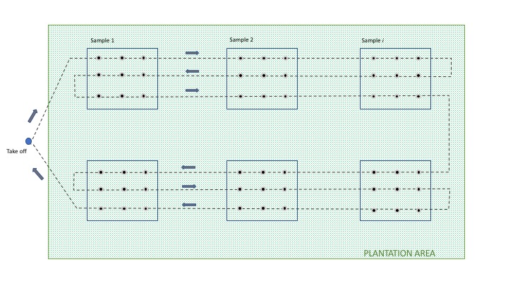
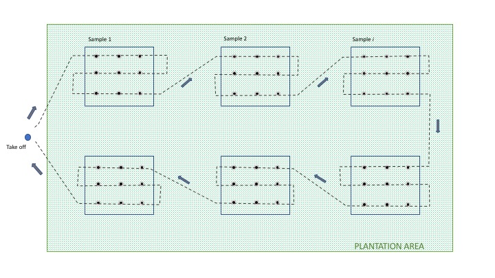
Hello. I am using MME for remote sensing on forest plantations, specially one year old tree counting on large areas, from 150 acres and more. On those large areas is redundant do a full mosaic of the entire plantation and perform a tree census, instead we create samples of small mosaics (3x3, 4x4, images) systematically distributed according to the tree plantation characteristics (statistical sample), then we perform the tree account on the sample to describe later the entire plantation. Now here comes the suggestion: Because each small mosaic is a unique flight plan we must do many flight plans (one per sample/mosaic) to cover the plantation with the corresponding loss of performance, so will be great if the map pilot app has a special feature to plan this kind of flight where is not necessary take images of the entire area, only capture images of parts where each sample is. I send two diagrams to describe the situation with different ways of addressing this problem:
 Thank in you in advance for your attention. Forgive my english, is not my mother tongue, i live in Argentina, South America.
Regards
iniciar sessão para comentar.
Interesting... But this looks fairly specialized and isn't likely something anyone else would use so we are not likely to add it to the Map Pilot feature list. Nice diagrams though.
Thank you, Zane, for your response. Yes, it is true, looks specialized, but
taking apart the specialized thing (tree counting), I see that MME points to other topics like agriculture. In this last could be possible that other users can find this feature interesting and useful. And that is because on large areas, where some studies are made, is anti-economic do a complete survey of the entire place; so, a sample is cheaper, accurate and fast to obtain information for a decision maker like our forestry customers today. We are also studying applying this method for extensive crops, like wheat, corn, sunflower, soybeans, etc. where a fast sample survey is enough to know health for example, or stress, soil humidity, etc. using near IR (sequoia). It is not rare this type of surveys in traditional studies related to the use of soil and natural resources. Technicians and producers around the world are using surveys like this every day.
Our original idea was to convert a traditional land survey method to an improved one taken from an aerial platform, this was based on a suggestion from a customer.
I understand MME is not likely to add it, but take it into account for the future. We did not find other apps from your competitors with this feature yet, especially on those related to precision agriculture (dronedeploy, pix4d, precisionhawk, mosaicmill, etc.). Thank you again Zane for your attention, I really appreciate it.
Regards
(Diagrams made with PowerPoint)

Santiago, as Zane said, what you want to do doesn't fit the Map Pilot/MME paradigm.
The way I see it there are two components to your problem.
1. Setup and fly a flight plan that takes images at the appropriate spacing in your sample areas.
2. Use MapsMadeEasy to create composited images for each of your sample areas.
I have a problem which requires that images are taken according to a specific flight plan rather than the automatic plan generated by Map Pilot. I am still experimenting but I am getting some very promising results using MME to create a photomosaic from my images.
I can think of a couple of ways in which you can generate and execute a flight plan similar to your first diagram. The second one is more problematic.
A discussion of this is not appropriate to this forum but if you want to contact me directly at ian821830@gmail.com I can discuss it further with you.
Great! Thank you Zane and Ian. I wrote a message to the email.

Take a look at Autopilot by Hangar. https://autoflight.hangar.com/
Use Waypoint planning.