Publicación

2 seguidores Seguir
0
Avatar

3D Mapping

Hi there. 

I have just tried to create my first full 3D map of a structure however, the quality has come out really poor and it does not look at all like the building in question. I am certain there is something I have done wrong but would be grateful if someone such as Zane could point me in the right direction as I know he can see the maps. The one in question is Sycamore. I used a grid mission to record the data. Perhaps my overlap was not enough? If so, what are the best settings for 3D? 

The detail is also not good from a general photogrammetry point of view either so again, I assume there is something I have not done correctly. Previous map i prepared I used the line mission

Look forward to hearing from someone.

Ross 

Ross Yeates

Comentario oficial

Avatar

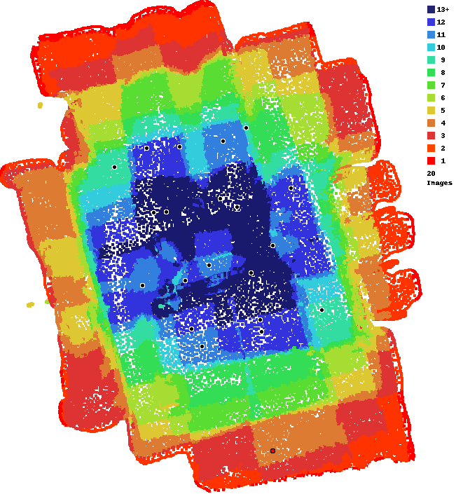
We are sorry to hear you are not happy with your results. For Full 3D work you need more overlap. The ideal overlap would be to give the system at least 25 views of everything you want to render. You only uploaded 20 images so that is going to be hard. You can see in your Overlap Report that the majority of your coverage area didn't have enough for even a normal map. 

Your most recent flight log shows an overlap of 65/80 overlap which isn't great. That is basically telling the app to collect roughly 15 views of everything. Even then, only the very middle of the area will get that. The edges all get less. 

The images also look pretty streaky. 

So... Use 80/80 overlap. Cover a slightly larger area. Fly when there is more light. Give the system lots to work with. 

You have a Pro subscription so you can upload up to 250 twelve megapixel images for free. 


Zane
Acciones de comentarios Permalink

Iniciar sesión para dejar un comentario.

3 comentarios

0
Avatar

Thank you Zane, as I mentioned above, I was quite certain it would be user error more than anything else. I will do as you say with 80/80 and open it up a bit wider although I cant go too much further to the left due to the houses there. The new mission plan I have prepared is covering 0.22 hect rather than the original 0.08 hect, so almost three times the size. I am using an altitude of 30m and a speed of 3.5m/s. Hope that sounds ok? Thank you again for the advice, I appreciate it.

Ross Yeates 0 votos
Acciones de comentarios Permalink
0
Avatar

Hi Zane

I created a new 3D map today, but the quality is still not good enough. If you could please let me know what else I can do or what I am doing wrong, I would appreciate it. 80/80, 90 photos taken, larger area. I am not sure what else I can do? This was also pretty much midday with good light as well.

Any thoughts appreciated.

Many thanks

Ross 

Ross Yeates 0 votos
Acciones de comentarios Permalink