
تعليق رسمي

There are a few things you can do to improve the accuracy of your elevation results.
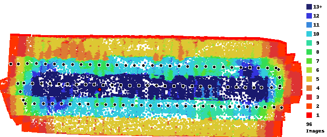
First, the shape of your mission is narrow and long. Without using lots of overlap very little of the area you are covering is actually getting the amount of looks the system needs to be getting. If you must limit passes like this you should use a much higher along track overlap setting so everything is dark blue in the overlap report, not just the very center.
Second, consistent imaging speed. All the images taken at the ends of your passes are taken while the aircraft is travelling very slowly and the rest of the images it was moving quickly. With a rolling shutter camera this mix of speed causes inaccuracy. Our Map Pilot Pro app addresses this issues (as do a few others). Setting the image timer and flying is not the way to take accurate data.
It should be accepting the ground image though even if it was flat. We will adjust things to make sure that gets through.