Post

2 followers Follow
0
Avatar

Negative elevations?

My processed project came back with elevations ranging from -400 to -700 feet elevation.  Site elevations should be about 0 to 300 feet msl counting the trees.  What happened??  I used a Mavic Pro 2 and Map Pilot app.  The project consisted of 4 flights (i.e. 4 batteries).

Erick Staley

Please sign in to leave a comment.

2 comments

0
Avatar

Waiting for a response, other posts have had responses from Zane.  Not only are the "elevations" below sea level, but the surface appears to be distorted.  I'm comparing the data to recent lidar and see some glaring errors.  (e.g. flat farm fields have 10+ feet in elevation difference where should only be 1-2 ft)

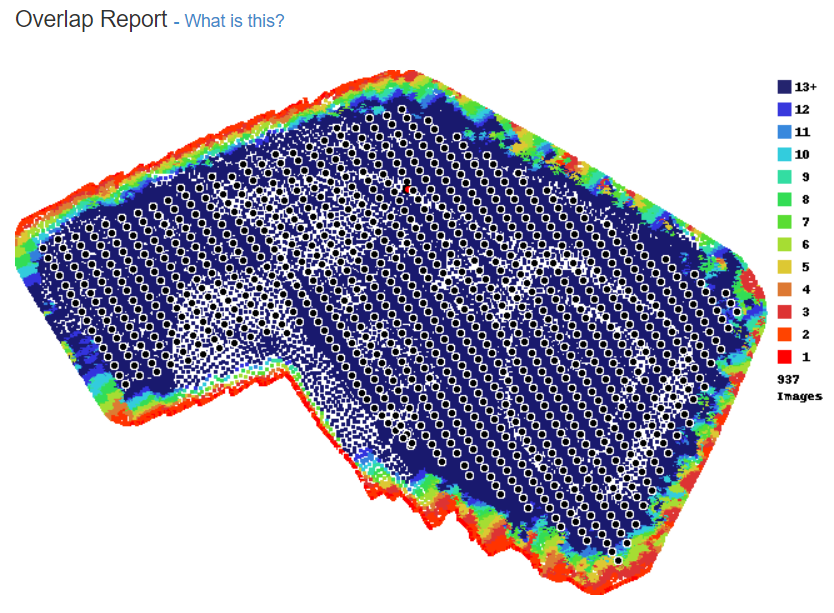
Overlap map is excellent.  Not sure what went wrong.  But I have a very angry client at this point with no explanation for the errors.

Erick Staley 0 votes
Comment actions Permalink
0
Avatar

Sorry. Must have missed this one. 

For the curvature including water in your map and having any reflections on it is one-way ticket to having an inaccurate map. This is why it is the first thing on the Data Collection guidelines that are agreed to at the time of upload. 

For the gross offset it looks like there might have been a problem with the barometric altimeter at the time of your flight.  

The relative altitude numbers are usually 0 at the takeoff (which was the case) and -102.9 meters (which seems very wrong). This made your adjusted flight height -69.4 meters. Your takeoff location's elevation was 33.4m and the correction was made properly but for some reason your image's relative altitude was recorded as being the same as the GPS derived number. This isn't usually the case. The relative altitude numbers recorded in the XMP tags of the images should have been a positive number that was equal to whatever height you set it to, not a negative value. 

You may want to do some smaller tests to verify that the Relative Altitude in the XMP tags is accurate before doing any more mapping work. Your most recent job does not appear to have had a Ground Reference Image included with it and it shows negative as well.

Luckily you had enough overlap that the visible map help together but the elevation map suffered. 

Zane 0 votes
Comment actions Permalink