Maps Made Easy makes sharing the data you create a breeze.
Sharing the Web Map
When you process a map with Maps Made Easy you get your private view of the map where you can manage its data and settings. This is where you would make your own measurements and make privacy settings. You can decide if anybody other than you can see the map. They would not view it using your Map Detail page. Instead they would use the public link.
Share with Link
From the Map's Detail page you will need to do two things: enable the sharing and copy the link.
All of the entries have a tool tip that is displayed when the title is hovered over. These tool tips are there to explain what each item does.
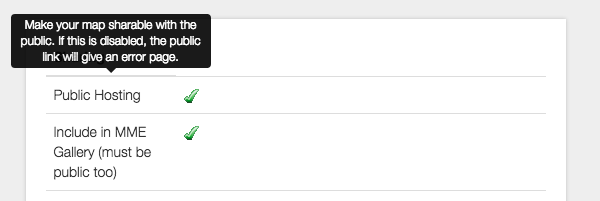
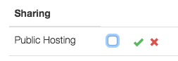
To modify the values of any of these settings the the user can click on the green check or the red X to change the value. This will bring up a check box that can be changed. For the change to be accepted (or rejected) clicking the green check or the red X next to the check box is required. The value will not be updated until the acceptance check and rejection X are gone and the new setting is shown.
In the example below, Public Hosting will not be turned off until the green check is clicked to accept the change. Clicking the red X would put the value back to its previous setting.
The public link can then be copied from the "Public Link" box that is available further down the Sharing section.
You can read more about his here: Sharing Controls
Share on your own page
The Map Detail page also contains an iFrame embed code that you can easily put in your own page to embed the web map right in your site for really professional looking results. Just copy the full code from the 'iFrame Embed Code' line in the Sharing section and put it in your own HTML.
You can see an example of this at work on our Samples page. Each map there is embedded using an iFrame.
Sharing Output Files
You can either download each of the files and send them on your own or you can just share the links to have people download them directly from us. You can do this by right clicking on the file download link and selecting 'Copy'. Then paste the download URL to whoever needs it. You can also copy and paste the full download section like this:
| Advanced Output | Download by Dec. 31, 2022, 11:51 a.m. |
|---|---|
| GeoTIFF (TIF) | Download (283.1 MB) |
| Full Resolution Image (JPG) | Download (23.5 MB) |
| DEM GeoTiff (TIF) | Download (17.3 MB) |
| Colorized DEM GeoTIFF (TIF) | Download (10.5 MB) |
| Colorized DEM (JPG) | Download (1.0 MB) |
Comments